In Search of Barnhardy
Copyright © 2003 by Richard S. Platz
All Rights Reserved
DeGarmo Canyon-Barnhardy Backpack
Hart Mountain National Antelope Refuge
June 1-8, 2003
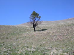
High desert in bloom;
Just once, and never again
Snow blanketed the high country, smothering forests thirsty from
years of drought. More precipitation had fallen in December than
in any month on record. April was the wettest ever. Yet two wet
months do not undo the ravages of prolonged drought. Beneath the
snows bark beetles were killing the weakened trees.
Phone calls to a half-dozen ranger districts told of heavy snows, frozen lakes,
and trails blocked by blown-down trees. In the Trinities Swift Creek trail was
closed half-way to Parker Creek. The road to Big Flat was open, but you could
not get to Caribou Lakes. In the Marbles the lakes in the Shackleford drainage
were still frozen. Snow covered the trails to North Yolla Bolly and Black Rock
Lakes. All trails above Pepperdine Campground in the Warners were still under
snow.
So where could we backpack?
On Sunday we loaded our backpacks into the van, uncertain if they would be
of any use. The temperature rose into the 90's along the Trinity River, making
it difficult to ponder snow drifts and frozen lakes. Somewhere along the way
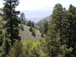
we decided to try backpacking in the Hart Mountain National Antelope Refuge.
Monday morning we took Highway 97 from Weed, climbed the Cascades
over Grass Lake summit, and drove through the arid Butte Valley
past Macdoel, Dorris, and on to Klamath Falls, where we caught
Highway 140 east to Lakeview. There we located the main headquarters
for the Hart Mountain Antelope and Sheldon Wildlife Refuges on
the second floor of the glass-and-aluminum-trimmed post office
building, which grew like a cubist mushroom from the fertile center
of the little cow town. Not many visitors apparently found their
way up the elevator, and the rangers there fairly fluttered to
tell us about their refuges. They called in the Head Ranger. "Sure
you can backpack there! Well, no, can't really remember anyone
else ever actually doing it. Where exactly? Well,
anywhere! It's a big place. Just crawls with
hunters in the Fall." They sent us off with armloads of maps
and full-color pamphlets, but without much clarity about where
we might be able to find water.
Highway 140 joins Highway 395 in Lakeview, jogs north a few miles, then separates
and shoots east again over the high volcanic Warner plateau. Halfway to Adel,
County Road 3-13, signed the Plush Cutoff, cuts off north to Plush, a tiny farm
community in a graben on the western shore of Hart Lake. Across the lake the
steep block fault escarpment of Hart Mountain rises as a 3000-foot wall, crowned
by snowcapped Warner Peak. We topped off the van's tank with regular (the only
gasoline sold at the Plush general store), bought a bundle of juniper firewood,
and continued along Road 3-13, now appropriately called Hart Mountain Road,
as it crossed the long levee at the north end of Hart Lake, then climbed north
up the alluvial fan at the base of the towering scarp. Pavement ended as we
entered the refuge, and signs announced that pronghorn antelope and bighorn
sheep could be viewed on the cliffs above, but even with slick new Pentax binoculars,
we saw nothing.
At an elevation of 5620 feet, the park headquarters of the Hart Mountain National
Antelope Refuge occupies a seventy-year-old stone building surrounded by graying
wooden barns and outbuildings. Located on Rock Creek at the intersection of
unpaved Hart Mountain and French Glen roads, the compound has the air of an
abandoned farmstead. The afternoon was hot and dry without a cloud in the sky.
Mirages shimmered over the wide expanse of sage descending east forty miles
into the Catlow Valley. A lone antelope bounded away from us as we drove across
the creek near the headquarters. No one was inside the main office, but we filled
out a back country registration card and thumb-tacked it to the bulletin board
per instructions, then perused the posted literature, photos, and maps.
Growing increasingly concerned about where water might be found, we rousted
a young ranger out of the equipment barn. Tan and sturdy with
a short blond crewcut, he wiped his hands on a red rag, reliably
at home in the unnerving expanse of sagebrush. His stance let
us know that he was not an interpretive ranger, no indeed,
and he had no time for fools. He confirmed that there were plenty
of places to go and spend a night or two. I asked about Willow
Creek, and the ranger said, fine, but thought DeGarmo Canyon or
Barnhardy would be a better choice. He refused to commit to any
water flowing in the canyons below Mt. Warner, in DeGarmo Canyon,
at Barnhardy, or anywhere else for that matter. Anyone who had
to ask about water, he implied, maybe shouldn't be out here. Here
a cowpoke finds such things out for himself, then keeps them to
himself. We thanked him, filled our water jug, and retired to
study the maps.
At the Hot Springs Campground a couple of miles up the road we found a campsite
in an aspen grove along Rock Creek. The ground was moist, but not muddy, so
we were able to drive right up to a stone fire ring in the willow and alder
thickets beside the creek. Only a few other vehicles were spread throughout
the various arms of the campground, none nearby. It had been a long day of driving.
 We
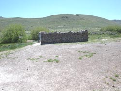
walked up the road to what remained of the bath house. Since our
last visit, the high stone walls had been broken down to about
four feet in height, and the entrance door removed. No longer
was a sign posted to lock the door and limit your time to 15 minutes
if people were waiting. Privacy was compromised, yes, but the
tradeoff was an expansive view from the hot tub of the surrounding
sage-covered hills. Overall, we agreed, it was an improvement.
No one else was around, so we doffed our cloths, climbed down
the rusty steel ladder into the rocky basin, and enjoyed a leisurely
soak as the natural hot water bubbled up through our toes from
the sandy floor. We
walked up the road to what remained of the bath house. Since our
last visit, the high stone walls had been broken down to about
four feet in height, and the entrance door removed. No longer
was a sign posted to lock the door and limit your time to 15 minutes
if people were waiting. Privacy was compromised, yes, but the
tradeoff was an expansive view from the hot tub of the surrounding
sage-covered hills. Overall, we agreed, it was an improvement.
No one else was around, so we doffed our cloths, climbed down
the rusty steel ladder into the rocky basin, and enjoyed a leisurely
soak as the natural hot water bubbled up through our toes from
the sandy floor.
The evening was sultry. We built our fire, cooked dinner, and laid back in
our folding chairs. Lots of birds flitted around us in the shrubs and lush grass,
which, unfortunately, also harbored a corps of whining mosquitos. They drove
us into the van shortly after sunset.
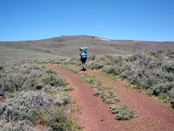
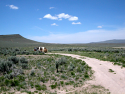
After breakfast on Tuesday morning we loaded our backpacks and reloaded the
van, then drove a quarter mile, past the campground hosts, and parked at the
gate across the Barnhardy Road in a meadow full of Douglas iris. Now open only
by special permit, the road consisted of two bare tire tracks snaking up into
the vast sagebrush hills. The trailhead elevation was just under 6000 feet
We began our hike around ten in the morning. Having never backpacked in the
desert before, we weren't sure what to expect. Our visions were of Georgia O'Keeffe
cow skulls bleaching in alkali flats while scorpions and rattlesnakes slithered
into our sleeping bags. The Sons of the Pioneers, Edward Abbey, and common sense
ordained that water would be of vital importance, so we each carried a spare
quart. As it turned out, we would find plenty of runoff from the April snows
that still clung to the north face of the highest ridges, gurgling through the
aspen groves of the deep canyons and feeding Rock Creek and the grassy meadowlands
surrounding Barnhardy.
 We
followed the road south into a gully and immediately encountered
an aspen grove with a stream trickling through. Continuing to
climb up and over a hill, we consulted the GPS for a trail junction
we had entered as a waypoint from the map. Exactly where the GPS
indicated the trail should be, we found a jeep road climbing west
toward the high divide, so we followed it. As we climbed, the
sage grew sparse and gave way to tundra of short bunchgrass and
lichen-painted volcanic rock. With another hour's hiking, we attained
a bald saddle in the divide ridge at almost 7000 feet, where we
decided to stop for lunch. A few hundred feet further south along
the ridge, at the bottom of a shallow swale, a small snowfield
beckoned, and we knew that if all else failed, we could camp there
and melt snow for water. We
followed the road south into a gully and immediately encountered
an aspen grove with a stream trickling through. Continuing to
climb up and over a hill, we consulted the GPS for a trail junction
we had entered as a waypoint from the map. Exactly where the GPS
indicated the trail should be, we found a jeep road climbing west
toward the high divide, so we followed it. As we climbed, the
sage grew sparse and gave way to tundra of short bunchgrass and
lichen-painted volcanic rock. With another hour's hiking, we attained
a bald saddle in the divide ridge at almost 7000 feet, where we
decided to stop for lunch. A few hundred feet further south along
the ridge, at the bottom of a shallow swale, a small snowfield
beckoned, and we knew that if all else failed, we could camp there
and melt snow for water.
As we munched our apple chips and cheese sticks, we looked through the binoculars.
The stone bathhouse squatted in the alkaline clearing at the Hot Springs Campground
whence we had started. We had hiked for half a day and could still see the bright
gleam of sun off our van's windshield. Distances were tricky in this vast treeless
wilderness. The landscape seemed a wasteland--barren, parched, inhospitable,
and more than a little frightening. In the distance to the east, the green slash
of Rock Creek ran down the massive sage-covered plateau toward the Catlow Valley.
Beyond that rose the Catlow Rim, the next fault scarp in a procession of fractured,
tilted blocks of crust. North of that we saw on the horizon a hallucinatory
white smudge which may have been the snows of distant Steens Mountain.
The spur road continued northwest to a higher plateau which, in a mile or
two, would attain the western edge of the forty-mile-wide block of crust, providing
a view down the scarp to Hart Lake and Plush more than 3000 feet below. Instead
of following the road, we dropped down the saddle to the snow patch, confirmed
it was not a mirage, then descended west off-trail into what we believed to
be the northern-most reaches of DeGarmo Canyon. For the next four days we would
wander beyond sight or sound of any other humans.
We cross-countried down the steep slope toward a slash of green
at the bottom of the gully, where we were delighted to find a
puddle of water. Not much, but encouraging. Then, a little father
down, a rivulet surfaced for a few feet before again sinking underground
in a patch of grass and stunted corn lilies. As we followed the
stream bed down the ravine, the water began to flow more frequently.
At the bottom, our spur gully emptied into the larger North Fork
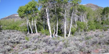
of DeGarmo Canyon in a comforting green sward of wet meadow, through
which our stream surfaced for good to feed a beautiful little
creek. Contouring left above the marsh, we hiked a quarter mile
up the creek to a sparse grove of aspen at 6800 feet. Corn lilies
and something akin to mule ears with bight yellow flowers sprouted
along the creek, and the thick riparian bunchgrass was spangled
with shooting stars and larkspur. We decided to spend our first
night there.
We searched our little oasis for signs of an old campsite. No
fire rings were to be found, no patches of ground cleared for
a tent site, no rusting soup cans nor beer bottle caps, no plastic
bags nor hanks of polypropylene rope. No sign was evident of humans
at all, except, far up the canyon to the east, what appeared to
be an abandoned line of barbed-wire fence.
 So
we built our own campsite in a flat area away from the creek.
We carried rocks up from the steam, dug away the turf, built a
small fire ring, and cleared fallen aspen branches away for the
tent. As we worked, we were harassed by bird activity in the nearby
trees. A red-tailed hawk flitted from tree to tree emitting piercing
cries. Barbara spotted its nest in an aspen a few trees away from
our tent site. The hawk was obviously not pleased with our company.
"Get over it," I called, and after a while the bird
did, sneaking in and out of its nest from the far side when he
thought we weren't looking. A few mosquitoes visited us in the
evening, but nothing a little bug juice couldn't handle. Not a
cloud menaced our outing. So
we built our own campsite in a flat area away from the creek.
We carried rocks up from the steam, dug away the turf, built a
small fire ring, and cleared fallen aspen branches away for the
tent. As we worked, we were harassed by bird activity in the nearby
trees. A red-tailed hawk flitted from tree to tree emitting piercing
cries. Barbara spotted its nest in an aspen a few trees away from
our tent site. The hawk was obviously not pleased with our company.
"Get over it," I called, and after a while the bird
did, sneaking in and out of its nest from the far side when he
thought we weren't looking. A few mosquitoes visited us in the
evening, but nothing a little bug juice couldn't handle. Not a
cloud menaced our outing.
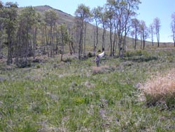
After dinner we explored our new neighborhood. Something was odd. Even by
high desert standards, the vegetation seemed unusually sparse. We kept stumbling
over blackened stumps of sagebrush in the thick grass and low sage and found
charred aspen branches partially buried under new ground cover. A sagebrush
fire had apparently raged through the canyon not too long ago, killing a few
of the shorter aspens and the lower limbs of the taller ones. The marvel was
how the vegetation was renewing itself.
On Wednesday we had to slap a few mosquitoes as we drank our hot morning beverages
leaning against an aspen log beside the burbling creek. A few small birds flitted
in the scrub after our hawk had sneaked out the back door of its nest. The sun
rose quickly in another cloudless sky, and the mosquitoes went away.
"Where do they go?" I asked.
"They?"
"The mosquitoes. When there's no blood to suck."
The sage-covered hills replied with a vast, peaceful silence, an intimation
that all mysteries had an ordinary answer, all things have their place.
Midmorning we zipped up our tent and began a march down DeGarmo Canyon, contouring
high on game trails as our little stream on the canyon floor fell away. We stumbled
occasionally on blackened stumps of burned sage hiding beneath the new growth.
A half mile below our camp we passed above two magnificent ponderosa pines flanking
a lush narrow meadow along the stream. Occasionally an outcropping of gnarly
volcanic bedrock pierced the pale green slopes. Before long we could see in
the distance a vertical notch at the bottom of a vee-shaped gorge, through which
the North and South Forks of DeGarmo Canyon spill into the valley below. As
we rounded each vertical ridge, circling ever leftward, new vistas were revealed,
dispelling the myth of "not much out here but sagebrush." Ponderosa
pines and junipers began to dot the steep slope, and then cluster together in
small groves. Yellow aspen, willows, riparian brush, and grasses choked the
creek, which grew in size and turbulence as springs and seeps fed it from beneath
green slashes in the canyon walls.
 Our
canyon circled southwest, then south, where it would join the
South Fork of DeGarmo Canyon near the western notch. We did not
make it as far as the confluence, but stopped for lunch at a good
campsite in a lush pocket forest of ponderosa pine, juniper, and
aspen with its own little stream running through and great views
through the gorge. Out across the valley floor lay Hart Lake,
Plush, and the snowy Warner Mountains in the distance. After lunch
we explored the area and found a distinct trail and another good
campsite a little farther along. We contemplated climbing up the
forested gully and dry slope above to the crest, then following
the GPS across the plateau and back down to our campsite. But
the climb of at least 500 feet would be taxing, hot, and dry,
and the unseen route uncertain. This was our first trip of the
year, and we were weary from the hike in. So we decided to go
back the way we had come. Our
canyon circled southwest, then south, where it would join the
South Fork of DeGarmo Canyon near the western notch. We did not
make it as far as the confluence, but stopped for lunch at a good
campsite in a lush pocket forest of ponderosa pine, juniper, and
aspen with its own little stream running through and great views
through the gorge. Out across the valley floor lay Hart Lake,
Plush, and the snowy Warner Mountains in the distance. After lunch
we explored the area and found a distinct trail and another good
campsite a little farther along. We contemplated climbing up the
forested gully and dry slope above to the crest, then following
the GPS across the plateau and back down to our campsite. But
the climb of at least 500 feet would be taxing, hot, and dry,
and the unseen route uncertain. This was our first trip of the
year, and we were weary from the hike in. So we decided to go
back the way we had come.
On our return we found a use or game trail of sorts leading down to a campsite
under the twin pines. The fire in that part of the canyon had left a lot of
burned branches to step over. On the hike up to our campsite we spotted two
antelope high above in the sage.
After dinner we took a walk toward a large aspen grove above our campsite
and saw a single antelope running along the ridge above us. This was calving
season, and the females are often seen protecting their calves. We backed off,
not wanting to scare her. Later we saw her standing and watching us for long
periods. It was great to have the fancy new Pentax binoculars to bring out her
intricate black-and-white markings. Back at camp a pair of western kingbirds
were arguing about where to build their nest, fluttering from tree to tree above
our campsite, oblivious to our presence. We also saw mountain bluebirds, house
finches, and lesser goldfinches.
Thursday morning we meditated leaning against our aspen log. The stream gurgled.
A mosquito whined. I composed my current Death Poem (better years
too early than a moment too late): Aspens tremble, kingbirds
shit on our tent. All is well.
We said goodbye to the watchful antelope and ascended southeast up the North
Fork of DeGarmo Canyon, circling counter-clockwise around a flat-topped mesa
of eroded rimrock. As we climbed, the stream disappeared into a broad wet meadow
of bunchgrass. Across the meadow to the south, at the base of the flank rising
toward the snowy slope of Mt. Warner, stood the large aspen grove where our
antelope made its home. The meadow was too soft and mushy to cross. A faint
path skirted the north margin of meadow and passed through an open gate in an
old barbed-wire fence, apparently no longer maintained. The path petered out
as the meadow gave way to thick sage brush, but we continued to climb gently
to the saddle. There we had to climb the exposed rimrock through a striking
stand of curly leaf mountain mahogany to the rim. At 7000 feet the rimrock dropped
off abruptly, and the Barnhardy valley lay spread out before us.
 Maybe
camping beside the stream in the aspens had awakened something
in our cellular memories. Or perhaps the sage had whispered its
secrets as we slept. But somehow the treeless landscape had lost
its menace and now began to make sense. It was as if the clothing
had been torn off, revealing the flesh of sage-covered hills,
freckled with the darker green of a few junipers, and the bones
of ancient lava flows poking through where water and ice had cut
canyons. On the flat rimrock crests of a few surrounding mesas
mountain mahogany grew in patches like tight brown crewcuts. In
the vees of the deeper canyons, between the legs of silver-gray
sage, grew pubic groves of yellow-green aspen. There we would
find our water. Maybe
camping beside the stream in the aspens had awakened something
in our cellular memories. Or perhaps the sage had whispered its
secrets as we slept. But somehow the treeless landscape had lost
its menace and now began to make sense. It was as if the clothing
had been torn off, revealing the flesh of sage-covered hills,
freckled with the darker green of a few junipers, and the bones
of ancient lava flows poking through where water and ice had cut
canyons. On the flat rimrock crests of a few surrounding mesas
mountain mahogany grew in patches like tight brown crewcuts. In
the vees of the deeper canyons, between the legs of silver-gray
sage, grew pubic groves of yellow-green aspen. There we would
find our water.
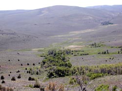
On the valley floor we could see segments of the Barnhardy Road as it wound
through the pale sage hills and slashed across a lush green sward directly below
us. Beyond, the meadow sloped down a swale to join Rock Creek. Through the binoculars
Barbara caught a glimpse of an old building in a grove of aspen near the road.
We decided to spend the night at Barnhardy. Ah, but whither lies that elusive
"Barnhardy"? The map showed it somewhere between the road and Rock
Creek, but nothing was evident from our vantage. We would drop down to the valley,
by god, and find it.
The hundred-foot scrabble down the rimrock face would have been slow and difficult
in any case, but with backpacks, it was treacherous. Loose stones slipped out
beneath our boots and clattered down the rock slope. When at last we reached
the sage-covered alluvial fan, the descent became easier, but was still steep
and occasionally interrupted by gnarly bedrock extrusions we had to climb around.
We contoured carefully southward toward a gully, where we encountered a rivulet,
the beginning of a stream, then followed the trickle down to an aspen grove
reaching all the way down to the Barnhardy Road.
The structure we had seen from the ridge was a shack squatting in the aspen
grove at the edge of a marshy meadow. We wanted to investigate, but the meadow
was too muddy to cross, so we skirted around to the road. To the left, the road
led back to our van. To the right, it dropped through a wet swale before climbing
the ridge toward Warner Peak and its snowfield. We turned right.
Water! The swale was awash with water. It sheeted across the road so that
we had to walk single file along a high rut and leap a stream
to keep from getting our boots wet. Surely the ranger at the visitor
center--the one who was not an interpretive ranger--knew
how much water was out here. But he refused to tell us. Good for
him! Ours had become a journey of discovery and was the sweeter
for it.
We were in quest of Barnhardy, which the map told us lay somewhere across
the road. But where? It had to be near water, probably on a stream feeding Rock
Creek below. As we hiked along the road toward Warner Peak, I made a few sorties
into the brush looking for signs of Barnhardy, but to no avail. No farmhouse.
No windmill. No barn. No corral. No road. Surely Barnhardy would become evident
farther up the road.
 After
hiking another mile to a place where two creeks poured across
the road, we suspended our search for Barnhardy and decided to
camp in a thick aspen grove just beyond the creek crossings. We
cleared a flat area for the tent, dug a small hole for a fire
pit, and lined it with rocks lugged in from the road. This shady
grove was much denser and wetter than our first campsite. Yet
beyond its verdant shore, the dry sagebrush stretched far and
away to the horizon. After
hiking another mile to a place where two creeks poured across
the road, we suspended our search for Barnhardy and decided to
camp in a thick aspen grove just beyond the creek crossings. We
cleared a flat area for the tent, dug a small hole for a fire
pit, and lined it with rocks lugged in from the road. This shady
grove was much denser and wetter than our first campsite. Yet
beyond its verdant shore, the dry sagebrush stretched far and
away to the horizon.
After setting up camp we stood back to admire the view, especially the rounded
mound of Warner Peak, its snowfield grinning at us like an idiot clown. Barbara
noticed a nest in the tree above our tent. Perhaps another red-tailed hawk?
Hoisting her new binoculars, she kept watch to see what, if anything, was nesting
there. After a while she discerned a head and two very long ears. Large, round
eyes seemed to watch us over the rim of the nest. That night we heard hooting
and knew for sure we were camping with a long-eared owl.
Friday was our day to hike out. We filled in our fire pit and dispersed the
rocks to leave no trace of our passing. We took down the tent, loaded up our
packs, and began the four-mile hike along the Barnhardy Road back to the van.
The walk through the sea of silver sage, dotted with green rabbitbrush, was
exhilarating. Out packs, lighter by 18 meals and two extra quarts of water,
felt buoyant. Prolific wildflowers grew along the way. The sky was clear blue,
the air fragrant with sage and juniper. An occasional mosquito whined in from
that unnamed mosquito limbo to spice the stew.
We passed the alder grove we had followed down from the DeGarmo Canyon divide,
passed the abandoned shack in the green sward of meadow, and crossed the wet
swale oozing down toward Rock Creek. Our road did not pass through the steep,
rocky canyon cut by Rock Creek on its course to Hot Springs Campground, but
climbed the hill to the west. At the saddle we passed the fork we had taken
on the way in, when we were different people, dropped through the little gully
with its stream and alders, and soon saw the sun glinting off the van windshield
more than a mile below.
We threw our gear on the bed of the van, to be sorted out later, and motored
the short quarter-mile to the hot spring bathhouse. No one was there--not surprising
in the mid-day heat. We rummaged for clean clothes, doffed our sweaty ones,
and clambered down the iron ladder into the bubbling mineral water. Ah, the
luxury of a hot soak at the end of the trail! Never have weary muscles so rejoiced.
At the headquarters, as we unposted our back-country permit as Lazarus might
have done on his return, we encountered the head ranger. "Ah, so you're
the ones," he said cheerfully. "In another day we would have come
looking for you."
We asked the whereabouts of Barnhardy, and he took us into his office and
pointed to a topo map that covered an entire wall. The matrix of thin lines
was overwhelming, disorienting, incomprehensible after so much sagebrush. Turning
from it, I asked specifically where Barnhardy was in relation to that shack
in the meadow beside the road.
"That shack," he informed us, "that was Barnhardy."
On to the Sheldon National Wildlife Refuge
We were bound for the Sheldon National Wildlife Refuge in northwestern Nevada,
where we had spent a pleasant couple of days car camping two years ago while
my hip recuperated. We considered only briefly the head ranger's recommendation
that we take the scenic route to French Glen, then south through Fields to Highway
140 near Denio. Having gone that way once before, having driven the van through
a herd of cattle headed up by horsemen and busting a tire north of Fields, we
knew the road to be unpaved, long, and slow. We were now on the downslope of
our vacation with only two more days to get home.
 So
we retraced the gravel road down the escarpment southwest to Plush,
then turned south to follow the graben to Adel. The towering scarps
closed in on both the east and west until we emerged into the
Crump Lake valley and Hart Mountain began to recede behind us.
At Adel, we headed east on Highway 140 through a pass in the Warner
Mountains, dropped into the Guano Valley, and climbed Antelope
Butte onto the vast high desert plateau again. Ten miles past
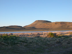
the Nevada line we crested a ridge and saw Big Spring Reservoir
below us nestled beneath the copper-colored castle of Big Spring
Butte. So
we retraced the gravel road down the escarpment southwest to Plush,
then turned south to follow the graben to Adel. The towering scarps
closed in on both the east and west until we emerged into the
Crump Lake valley and Hart Mountain began to recede behind us.
At Adel, we headed east on Highway 140 through a pass in the Warner
Mountains, dropped into the Guano Valley, and climbed Antelope
Butte onto the vast high desert plateau again. Ten miles past
the Nevada line we crested a ridge and saw Big Spring Reservoir
below us nestled beneath the copper-colored castle of Big Spring
Butte.
Our old campsite was empty, so we set up our stove and chairs, emptied the
bed of the van, and deployed our Traveling Van Buddha smartly on the Orange
Wonder table. Not many people were around. The lake had dropped, receding far
from our camp on the shallow lake floor. We spotted a marsh hawk in the reeds
by the water, much farther away than last time. No fledglings crashed through
the brush to amuse us. The chicks probably had not yet hatched.
On our evening stroll along the lake shore we saw avocets and herring gulls.
Then Barbara noticed that something was kicking up an enormous cloud of dust
across the lake. With the binoculars we observed wild horses frolicking on the
shore perhaps a mile away. A constant stream of newcomers galloped down from
the hills to join them. Back at camp we set up the spotting scope and watched
the horses romp. We counted more than 100 of them rolling, splashing, and galloping
around in the throes of some primordial mating rut. Neither of us had ever seen
anything like it before. We watched until it grew dark. Mosquitos were not too
bad, but we went to bed early, then woke up to watch the red crescent moon setting.
We saw only two other campers at Big Spring.
Morning at Big Spring was leisurely and peaceful. Before packing up, we watched
a butterfly patiently explore the green cap of a plastic orange juice bottle
on the table. What was it finding? Were its discoveries any less than ours?
We followed Big Spring Creek down the valley to the Dufurrena Ponds, drove
past the refuge sub-headquarters, then followed a gravel road another mile to
Virgin Valley campground for a swim and a shower. The pool was large and the
water cool, but not cold. Children splashed in the shallows while parents watched.
Inside the private bathhouse, two shower heads constantly sprayed the inexhaustible
supply of natural hot water. No valves had been installed to turn them off.
The campground was surprisingly tidy. Something sinister had been swept away.
Frightening figures no longer lurked among rundown trailers. Sylvia, the campground
host, apparently made the difference. The locals have formed a historical society,
cleaned up the place, and plan to restore the sandstone block armory as a museum.
We made a small cash donation to the project. I wanted to take something home
for our neighbor Mark, who is a rockhound. Sylvia gave us several chunks of
petrified wood with black fire opal which she had found abandoned by rockhounds
passing through.
We asked her about the shortcut through the refuge to Cedarville, and Sylvia
told us the gravel roads are fine. She goes that way all the time. She recommended
turning right on Road 34A, the scenic route. We backtracked on paved Highway
140, then turned south into the desert on gravel Road 8A. When we arrived at
Road 34A, we turned right, as Sylvia recommended. The road immediately grew
narrow and rocky and began to climb. Our speed dropped from 25 mph to 10. We
still had a long way to go to get home. After a half mile, we managed to turn
the van around, returned to Road 8A, and continued on the better road to Cedarville.
 We
stopped for lunch at a place called Fish Spring Campground. There
was nothing there. No fish. No spring. No shade. No people. Just
a sign, a wire corral, and an empty loop of road beside a tinge
of green on the edge of a barren alkali flat in a sea of desert
sagebrush. The only sound was the wind. Barbara was uncomfortable
stopping the engine. What if we couldn't get it started again?
Out here, without water, where nobody came along for days at a
time, a mechanical failure could be life threatening. We
stopped for lunch at a place called Fish Spring Campground. There
was nothing there. No fish. No spring. No shade. No people. Just
a sign, a wire corral, and an empty loop of road beside a tinge
of green on the edge of a barren alkali flat in a sea of desert
sagebrush. The only sound was the wind. Barbara was uncomfortable
stopping the engine. What if we couldn't get it started again?
Out here, without water, where nobody came along for days at a
time, a mechanical failure could be life threatening.
"Nothing's going to go wrong," I assured her stuffily and ate a
cheese stick.
The engine started with a cough. Road 8A led us down off the plateau into
the Surprise Valley, then became paved Route 299 when we crossed into California.
The high peaks of the Warner Mountains were deep in snow. We passed through
Cedarville, the Cedar Pass, and Alturas, then followed the Pitt River west.
Near Burney we cut south on Highway 89 to spend our last night at Hat Creek.
From Hat Creek the drive was easy. We breezed through the valley heat of Redding
with the van's air conditioner running full blast, enjoying the cool air pumping
out of the vents on such a hot day. Somewhere along the Trinity River Barbara
suddenly reached over and punched off the air conditioning.
"Wha's'a'matter?" I asked.
"The temperature gauge is reading high."
"Oh . . . good work. Keep an eye on it."
Not a minute passed before the needle jumped to the top of the gauge and steam
began to ooze through the vents with an aroma of hot antifreeze.
"Pull over!" I yelled.
"Where?"
"Anywhere!"
We rounded a right-hand curve and a long, broad, gravel pullout appeared on
the left between the road and the river. Barbara wheeled the van across the
oncoming lanes, slid to a stop in the gravel, and switched off the motor. Stunned,
we sat in the rising heat and watched steam pour out from under the hood.
We opened the hood and waited for the motor to cool down. An occasional car
whizzed by. Below the ledge the Trinity River surged down its gorge. On the
other side of the road towered a sheer rock cliff. A small rivulet trickled
down its face. The noonday sun blazed down. We had no shade. Our cell phone
didn't work in the mountainous terrain
While I stared uncomprehendingly at the greasy motor, Barbara pushed through
the brush and poison oak and began filling the jugs from the water trickling
down the face of the cliff. When both jugs were finally full, we readied the
van. I topped off the radiator and jumped into the driver's seat. Barbara stowed
the water. The engine roared to life and we spun onto the highway. After a mile
the temperature gage began to rise. In another half mile it was over half-way
up. I pulled the van off at a short pullout on the right, and again we waited
in the breezeless heat for the engine to cool down so we could refill the radiator.
We finally made it to Cedar Flat and talked a young kayaker couple into driving
us to Willow Creek so we could get a tow truck. They said they were low on gas.
Indeed, their car ran out on the long incline just short of Willow Creek. We
hiked with the young man the last quarter mile or so discussing probability
theory and took our leave at Buddy's Towing.
The problem turned out to be a hole in the upper radiator hose. And the radiator
was shot. The God of Deferred Maintenance can be wrathful. In tribute, we replaced
the radiator, all belts, hoses, plugs, and wires, and had the rear brakes redone.
What had we learned? For one thing, we had dodged a bullet out in the high
desert. For another, the desert is not the barren wasteland we had supposed.
Were we reborn in the desert? Of course. Does enlightenment last? No. As Omar
Khayyam says, the moving finger, having writ, moves on. The fat lady never stops
singing.
Return to Backpacking
in Jefferson
|