Shoshone
Mike's Stronghold
Copyright © 2005-07
by Richard S. Platz, All
rights reserved
(Click on photos to enlarge)
Little High Rock Canyon Backpack
Little High Rock Canyon Wilderness
Black Rock Desert National Conservation Area
June 4-12, 2005
"Road signs riddled with bullet holes"
In the Spring of 1868 the transcontinental railroad
dragged its greasy belly down from the High Sierra and crawled
east across the high desert basin toward Promontory Point. Whores,
gamblers, pistoleros, and swindlers of every ilk, smelling opportunity,
dropped like ticks off the clanking beast at the newborn town
of Reno on the Truckee River in the Nevada territory. Their
prey were the miners and merchants of the Comstock Lode in Virginia
City and Gold Hill and emigrants still jarring along the California
wagon trails. Thus were sown the seeds of Nevadan character.
Reno and Sparks have since grown into a turbulent
cesspool of mindless development, swamping the Truckee River
Valley with high-rise casinos and shopping malls, factories,
freeways, and low rent housing, and overflowing into adjacent
desert valleys. Manifest destiny has gone mad. With an atavistic
frenzy the inhabitants still embrace legal prostitution, gambling,
and firearms. Jeep tracks and mine tailings scar the desert
and surrounding hills. Road signs are riddled with bullet holes.
Ah, but to the north of this madness lay the territory
we longed to visit, where the tap root of frontier mind draws
sustenance from the austere alkali playa of the Black Rock Desert.
The place has been popularized by the Burning Man Festival,
which blooms and fades like a desert flower one week each September.
But we wanted to go there not because Burning Man would be
there, but because it would not. We wanted to see the
land with cattle and sheep as its sole inhabitants. When no
traffic would meet us on the dusty gravel byways. We wanted
to see the land as it was seen from a Conestoga wagon following
the Lassen Trail.
Much we did not know about that remote
landscape and what grew there. How the Nevada desert nourishes
a depraved twist of mind. Where genocide is labeled "frontier
justice." Where long after the Indian Wars concluded elsewhere,
the Sheriff of Elko County urged citizens to "kill all
the Indians, and every Indian that may be found roaming the
Idaho country." (Twin Falls Times, Thursday, May
12, 1910.) Where as recently as 1911 a posse hunted down and
savagely massacred an impoverished band of Paiutes. All but
four children. For we had not yet heard of Shoshone Mike.
Unspoiled wilderness is not something the Nevadan
mind holds in high regard. Hell, spoiling things is half the
fun! So it came as a shock when Congress, in the last days of
Clinton's Presidency in 2000, designated three-quarters of a
million acres as wilderness in the Black Rock Desert, High Rock
Canyon, Emigrant Trails National Conservation Area. Now that
the land was liberated from off-road vehicles spewing beer cans,
bullets, and country music, we wanted to explore there. The
first week of June 2005 gave us a perfect opportunity. Weather
forecasts called for scattered showers and thunderstorms and
temperatures fifteen to twenty degrees below normal. Perfect
desert weather, we decided.
Gerlach, Nevada, would be our portal into the
Black Rock Desert. Two roads led thither from Cedarville in
the Surprise Valley of Northeastern California. East, just across
the Nevada line, unpaved County Road 34 wound south from Vya
through the scenic desert hills. But we were in a big hurry
to get to Gerlach and get started, so we chose instead
the faster two-lane blacktop of Highway 447 as it traced the
valley south. We had no idea we would be seeing plenty of Road
34 before long.
Gerlach squats at the waist between two merging
deserts, the Black Rock to the northeast and the Smoke Creek
to the southwest. There a spring seeping from the base of the
Granite Range provided water and forage for pioneers taking
Noble's Cutoff on the Applegate Trail. The town later became
a watering stop for thirsty steam locomotives on the Western
Pacific Railroad. Diesels now pull long freights through town
without slowing.
Expecting little, we were yet disappointed. Gerlach
has no general store. No gas station. No museum. No roadside
attraction. Just a crossroads with a few featureless houses,
beached like dead whales on the edge of the vast alkali playa
and dusted a ghostly white. Two businesses were open. One was
a gloomy casino, cafe, and windowless motel called Bruno's,
the other the local office for the Burning Man. A kiosk beside
the old railroad water tower offered a terse BLM pamphlet warning
travelers in the National Conservation Area of muddy sinkholes,
blown tires, and death by dehydration.
The only store was at Empire, seven miles further
down the road on the other side of the desert. As we crossed
the playa on the ribbon of two-lane, a primordial terror crept
like a spider across the back of my mind. The featureless sweep
of vast white space overwhelmed reason. But the panic receded
with the playa, and we pressed on to Empire, company town of
the Empire Gypsum Company, where we ate sandwiches, purchased
supplies, and topped off our water jugs. It was time to make
a decision.
We had been able to find scant literature on the
Black Rock Wilderness. Wilderness, as defined by the federal
government, does not sit well with the Nevadan temperament.
Unlike the Desolation and South Warner Wildernesses nearby in
California, no permits are required in Nevada, no trail maps
or descriptions available, and no fire or use rules published.
No road signs point to wilderness access. Trailheads are unmarked.
Parking is not designated. Even wilderness boundaries are unclear.
Cell phones and weather radios are worthless. Our GPS, an old
pre-wilderness Sierra Club guidebook, and contour maps were
all we had to go on.
Arbitrarily we agreed on the first hike in the
guidebook, a climb up McGill Canyon toward 8850-foot King Lear
Peak in the Jackson Mountains rimming the Black Rock Desert
on the northeast. There would be no trail, but we could find
and follow McGill Creek as we climbed and camp along the stream.
It looked like about a 75-mile drive on gravel roads. We headed
back toward Gerlach, then, before recrossing the playa, turned
north on the gravel Road 2048 signed "Trego Hot Spring
17 mi."
The road started out fine, rising and falling
through the foothills above the playa, roughly paralleling the
BNSF railroad tracks. But soon the surface became rough with
sharp-edged rock. I slowed down to protect the tires. Little
black spots on the road seemed to be hopping and crawling toward
the playa. I tried to blink the spots out of my eyes. "Do
you see things crawling across the road?"
Barbara squinted through the windshield. "Are
they moving?"
We topped a rise, and the road was covered with
hundreds of them. Thousands. "What the hell are
those . . . things!" I screamed.
I slowed the van and Barbara leaned out the window.
They looked like giant crickets, maybe two inches long. Too
fat to fly.  The
creepy black-brown insects flowed west across the road in disorienting
waves. Our skin crawled. Giant nuclear mutant bugs were breeding
in the desert. Maybe feeding on tourists. We dared not stop.
The
creepy black-brown insects flowed west across the road in disorienting
waves. Our skin crawled. Giant nuclear mutant bugs were breeding
in the desert. Maybe feeding on tourists. We dared not stop.
Later we learned the little buggers are called
Mormon Crickets. Not true crickets, they are shieldbacked katydids,
and not the least carnivorous. In June of 1848 millions of the
insects began to devour the crops of Utah pioneers. Settlers
fought them without success and faced starvation. Then, in the
"Miracle of the Seagulls," a white cloud of California
gulls descended, gorged themselves on the crickets, threw up,
and ate more, until the crops were saved. Can you say hallelujah!
Apparently they are now a plague on the town of Empire. Prayer
has so far proved ineffectual.
After a few miles the infestation thinned. Soon
the bugs disappeared altogether. Our top speed was still only
25 mph, but the odometer told us we were approaching Trego Hot
Spring. We thought we might test the waters there, maybe even
spend the night and carry on to McGill Canyon the following
morning.
There were, of course, no roadsigns. Occasionally
parallel tire tracks would wander off into the sagebrush on
the right or down to the playa on the left. But none were signed.
The day was too warm to see steam rising from the hot spring.
No other vehicle passed us. In a moment of inspiration, I plugged
the GPS into the laptop, which found our road on the electronic
topo map. Barbara watched the blinking cursor move along the
road and called directions for turns. Unfortunately, the location
of the hot spring on the topo map was off by a quarter mile.
For a testy moment we considered, then dismissed the bumpy track
into the sage indicated by the map. Instead we followed well-worn
tire tracks to the hot spring (N40 46' 18.1", W119 07'
02.4").
Ah, this was what we
were here to experience. Surrounded by miles and miles  of
uninhabited sagebrush and desert playa, we had Trego Hot Springs
all to ourselves. Forty feet from the railroad track, 200-degree
water bubbled up into a pool that fed a long trench. There it
merged with cooler water, then spread out into a green oasis
of reeds and rushes. A "T" of welded iron rail at
the center of a flat area marked the Emigrant Trail, where pioneers
had once set off toward the Black Rock in the middle of the
desert, trusting there to find the next spring.
of
uninhabited sagebrush and desert playa, we had Trego Hot Springs
all to ourselves. Forty feet from the railroad track, 200-degree
water bubbled up into a pool that fed a long trench. There it
merged with cooler water, then spread out into a green oasis
of reeds and rushes. A "T" of welded iron rail at
the center of a flat area marked the Emigrant Trail, where pioneers
had once set off toward the Black Rock in the middle of the
desert, trusting there to find the next spring.
As we were unloading the van in the middle of
the broad flat, we heard the growl of approaching motors. Three
full-sized pickups, each with a hulking camper overbalanced
on its back, rocked and trundled up the alkali road. One by
one the campers parked alongside our van, and three middle-aged
couples unfolded themselves stiffly from the cabs. Barbara,
being amicable by nature, engaged them in conversation.
I was too miffed to join in. This was trailer-park
mentality at its worst! Four vehicles huddled together in
the vast desert emptiness as if circled against some hallucinated
Indian menace. I promptly began tossing chairs and tables back
into the van to by god find a more remote site. Sensing my mood,
Barbara let me go. For fifteen minutes I tried one place after
another, driving in widening circles in a futile attempt to
escape. I was growing increasingly homicidal when at last I
pushed the van around the end of the hot spring and up a rough,
narrow path to a bare patch of ground 300 feet away between
a dune and the railroad tracks. There I stomped on the emergency
brake.
By dinner's end, my mood had brightened. In the
distance to the northeast we identified the craggy spires of
King Lear Peak blazing orange in the setting sunlight. They
looked impossible far away, and we considered rethinking our
next destination. The wind picked up and began to blow cold.
West across the playa heavy black clouds gathered over the peaks
of the Calico Range. By sunset the wind howled, blowing over
our lawn chairs and everything else not tied down. The clouds
looked nasty. We turned in without soaking in the hot spring.
That night it rained a little. To my delight, every 90 minutes
the blaring horn, rumble, and roar of a passing freight woke
us.
 Tuesday
morning we arose early to calm winds and cold sunlight slanting
across the desert. Fresh snow dusted the upper slopes of the
Calicos. Wrapped in a towel, I padded over to the hot spring
and eased down the slimy bank. Barbara caught my photo just
as a BNSF freight rumbled past, then joined me in the soothing
hot water. All was well with the world.
Tuesday
morning we arose early to calm winds and cold sunlight slanting
across the desert. Fresh snow dusted the upper slopes of the
Calicos. Wrapped in a towel, I padded over to the hot spring
and eased down the slimy bank. Barbara caught my photo just
as a BNSF freight rumbled past, then joined me in the soothing
hot water. All was well with the world.
After breakfast we repacked the van. One of the
campers was having trouble starting his diesel engine. They
had pushed the truck around and opened the hood so the sun would
warm the glow-plugs. We chatted for awhile. One of the men explained
how they had once camped at Little High Rock Canyon, and recommended
it. The canyon was beautiful. He described the entrance road
circling a reservoir and ending at a grassy meadow.
We had already decided not to follow the rocky
road on to King Lear Peak. For that we might return someday
in a rented four-wheel-drive. So we retraced our route to Bruno's
Casino and Cafe in Gerlach. As we ate lunch, we reviewed our
literature. The Sierra Club guidebook had a provocative description
of Little High Rock Canyon, and the west entrance appeared accessible
by passenger car from State Road 34. On the laptop I found the
coordinates of the turnoff and entered them into the GPS. After
lunch Barbara visited the Burning Man office and learned that
the festival was held at a BLM site on the playa accessed at
the nine-mile turnoff north of Gerlach on Highway 34. We decided
to check it out on our way.
 Gingerly
we drove down the access ramp and out on the playa, parked,
and got out, scuttling like ragged claws across the floor of
extinct Lake Lahontan, its surface once 500 feet above our heads.
The ancient lake vanished shortly after the Pleistocene epoch,
leaving only Pyramid, Winnemucca, and Walker Lakes and the Carson
Sink as its remnants. The playa was huge and featureless, blindingly
white, and disorienting. Distant mountains reflected in the
mirage shimmering above the alkali surface as we strolled away
from the van, which soon appeared minuscule and insignificant.
A man could get lost out there, or stuck in the cloying white
mud that followed a rain storm. A man could die of thirst. We
found no sign of the Burning Man.
Gingerly
we drove down the access ramp and out on the playa, parked,
and got out, scuttling like ragged claws across the floor of
extinct Lake Lahontan, its surface once 500 feet above our heads.
The ancient lake vanished shortly after the Pleistocene epoch,
leaving only Pyramid, Winnemucca, and Walker Lakes and the Carson
Sink as its remnants. The playa was huge and featureless, blindingly
white, and disorienting. Distant mountains reflected in the
mirage shimmering above the alkali surface as we strolled away
from the van, which soon appeared minuscule and insignificant.
A man could get lost out there, or stuck in the cloying white
mud that followed a rain storm. A man could die of thirst. We
found no sign of the Burning Man.
As we left the playa and climbed toward the western
slopes of the Calicos, the pavement ended and the gravel road
climbed up the canyon carved by South Willow Creek. Though well
graded, the gravel gave way to steep, rocky dips where the creek
flowed across the road. There a vehicle might get mired and
swept away in a flash flood. The van fishtailed across two particularly
treacherous crossings.
Where the GPS told us it should
be, there was no turnoff to Little High Rock Canyon. No road
sign. But back to the east was a cleft in the mountain rim we
judged to be the canyon. A little further along, six-tenths
of a mile north of the Duck Flat Road (N41 13' 34.6", W119
29' 26.6"),  we
found a rough, unmarked dirt track descending into the sagebrush
toward the canyon. We crawled down the narrow, bumpy road, gunning
across a few muddy ruts, hoping we would not have to turn around.
We came to a fork, both roads appearing equally traveled. We
chose the one to the right, which curved toward the canyon.
(Later we learned the left fork led to Denio Camp.) Our track
circled above a dammed reservoir (just like the fellow at Trego
had said), a quarter full of water, then dropped to a muddy
stream crossing in the middle of a broad wet meadow. For 30
feet the road was a bog where the stream flowed through deep,
muddy ruts. We parked the van, a little over four road miles
from Road 34.
we
found a rough, unmarked dirt track descending into the sagebrush
toward the canyon. We crawled down the narrow, bumpy road, gunning
across a few muddy ruts, hoping we would not have to turn around.
We came to a fork, both roads appearing equally traveled. We
chose the one to the right, which curved toward the canyon.
(Later we learned the left fork led to Denio Camp.) Our track
circled above a dammed reservoir (just like the fellow at Trego
had said), a quarter full of water, then dropped to a muddy
stream crossing in the middle of a broad wet meadow. For 30
feet the road was a bog where the stream flowed through deep,
muddy ruts. We parked the van, a little over four road miles
from Road 34.
We looked the place over. An amazing abundance
of cow pies adorned the green sward, and cattle watched us from
the surrounding tall sage. Bits of black obsidian peppered the
rocky, alkali dirt. Here at the stream crossing, we agreed,
would be a fine spot to camp. We locked the van to explore further
down the road.
On the far side of the muddy
crossing the road climbed a hill, then forked. The right-hand
fork wound down toward the cleft in the mountain, which, as
we approached, began to look like a chocolate-lemon layer cake
that had been sliced open and a single piece removed. Sage frosted
the slopes like mint icing. This had to be the mouth of High
Rock Canyon. We followed the road for a half-mile until we came
to a gate at the canyon's narrow entrance.  A
barbed-wire fence stretched high enough up into the rim rock
on each side to keep the cows out. The wire gate, of course,
lay wide open in neglect or defiance. This was Nevada. No signs
were posted, but we surmised that we stood on the threshold
of the wilderness (N41 15' 23.3", W119 25' 02.7").
A
barbed-wire fence stretched high enough up into the rim rock
on each side to keep the cows out. The wire gate, of course,
lay wide open in neglect or defiance. This was Nevada. No signs
were posted, but we surmised that we stood on the threshold
of the wilderness (N41 15' 23.3", W119 25' 02.7").
Tentatively we took a few steps into the canyon's
mouth. The walls were stunningly high rock cliffs, the bottom
beautifully green and inviting. A definite trail followed the
creek along the canyon floor, but we could not see past the
first bend, so we could not tell how far. We lingered a while
before returning to the van, closing the gate as we departed.
On the way back, at a ten-foot high strata of
white alkali deposits exposed in the cliff above the road, we
saw a short line of white tines sticking up like an overturned
xylophone. We climbed up to investigate. There, before a shallow
cave, lay the skeleton of a complete dead cow, ribs sticking
into the air and a bit of hide still clinging to the hoofs and
snout. We wondered if it had died naturally in that unlikely
place, or if someone (or some thing) had dragged it there
to eat, or as a warning to wolves, or rustlers, or to keep the
herd in line, or for some mysterious dark ceremonial purpose
only the Nevadan mind could grasp.
That evening, as we ate dinner, cows began to
crowd around us. I threw a few lame rocks, but they refused
to disperse. They faced our van in a picket line like disgruntled
Teamsters striking for a new contract. With maddening bovine
inscrutability they watched us eat. What did they want from
us? Were we blocking their path? Or did they want us to feed
them? We did our best to ignore them, and after a while they
slowly melted back to their forage.
It rained a little on Wednesday morning, turning
the soil and cow manure into a muddy paste that cemented in
the waffle soles of our hiking boots. Then a bright sun played
peek-a-boo with the lingering low clouds. As we lounged at the
campsite, we saw a grey flycatcher, robins, a shrike, and killdeer.
A melodious bird sang from hiding in the sage. Mid-morning coyotes
wailed nearby, reminding us of the ceremonial cow skeleton down
the road. We decided to spend the day reconnoitering in the
canyon to see if the trail ran all the way down and whether
there would be any place to camp.
Before noon we started into the canyon with daypacks,
immediately crossing the shallow creek on wet rocks. The canyon
curved sharply right, then slalommed back and forth beneath
ever rising rimrock painted yellow with lichen. As we hiked,
the canyon opened. The trail cut through tall sagebrush, eight-feet
high in places, and crossed and recrossed the creek as it meandered
from wall to wall. Growing in and along the stream were willow,
western serviceberry, rye and bunch grass, wild rose and current,
chokeberry, and, as we each painfully discovered, nettles. Larkspur,
penstamon, phlox, yellow Mariposa buttercup, and other flowers
we did not know brightened the slopes and meadows. Ahead swallows
and magpies flew among the cliffs, and a red-tailed hawk soared
high above. Barbara heard the descending trill of a canyon wren.
We found no sign of campsites or fire rings in
the brush. But there was a massive quantity of horse and cow
manure along the well-used corridor, which was probably a thoroughfare
for working buckaroos. In places the creek grew still, deep,
and muddy with alkali runoff turning the water milky. We wondered
if our water filter would clog if we tried to camp in the canyon.
Above us in the rimrock on the north slope several caves offered
spooky shelter. The entrance of the largest one was barred by
an elaborate grid of rusting welded-iron strap, the only sign
of human presence in the canyon.
After a while the floor of the canyon broadened
into a 300-feet wide pastureland. Sagebrush grew short and sparse,
replaced by lush green rye and bunch grass. We encountered no
grazing cattle. Overhead a peregrine falcon flew from wall to
wall, keeping a wary watch on us. When we stopped for lunch,
the bird flew to its nest at the mouth of a hanging side canyon.
A group of large raucous birds, gray with boldly barred flanks,
scolded us from the rimrock. We later keyed them out to be chukar.
"What's that?" Barbara asked, pointing
out a square plaque at the base of the towering cliff across
the creek to the south. It appeared to be a grave marker, or
a memorial to someone coldcocked by a falling slab of rock.
Even through the binoculars, Barbara could not quite make out
the words. So I hopped and squished across the creek to approach
the plaque. It read:
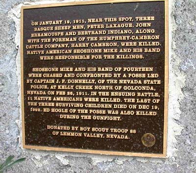
I found the Boy Scout marker annoying. The
whole thing felt wrong. Discordant. From its rectangular
carcass reeked the aroma of rotting fish and indoctrination. Like
the stench that must have filled the halls when Hitler Youth were
taught Aryan Supremacy. Or Andrew Jackson preached Manifest Destiny
to land-hungry pioneers. Those bright-eyed little Boy Scouts,
all wrapped in their flags and honor, had been fed the party line
by some crew-cut scoutmaster not born when the incident took place.
I wanted to hear the Indians' side of the story. Not until we
returned home, however, was I able to dig out the complete story
of the sad and sordid affair known as the "Last
Indian Battle".
We hiked out beneath threatening clouds and intermittent drizzle,
arriving back at the van around 4 P.M. The wind had picked up.
As we pondered what to do, a bright yellow-and-black bird serenaded
us from a stalk of sage. It was the Meadowlark we had heard,
but not identified, that morning. After dinner we followed a
spur road as it wound up the hillside above our camp. In the
distance to the east we saw a mineshaft or shelter of some sort
not far from the van. We crossed the creek and followed the
road up the east fork until we came to an old homestead, with
a collapsing shack built into the side of hill. The map identified
the place as Woodruff Camp. It appeared long abandoned by sheep
herders and buckaroos.
That evening we heard the coyotes again. In the
night, something thumping and scraping beside the van, awakening
Barbara. She told herself it was only cattle and fell back asleep.
Thursday morning the sky was clear and the sun
warm, although thunderclouds still ringed the horizon. As we
contemplated the ambiguous weather, Barbara identified a sage
thrasher and brown-headed cowbird. I wanted to try backpacking
into the canyon for at least one night. It had been ten months
since our last backpack. Our last weather report, though a week
old, had talked of a warming trend in the latter part of the
week. Barbara expressed concern about getting caught in a flash
flood in the canyon, but reluctantly agreed. But by the time
we had loaded and strapped on our packs, the noose of dark clouds
had tightened. Maybe it would pass over.
Once again we hiked down the road, past the ceremonial
cow skeleton, and through the gate into Little High Rock Canyon.
The familiar trail made for easy hiking. By noon we had reached
the broad pasture that I now thought of as Shoshone Mike's stronghold.
The sky had completely clouded over.  Before
we could find a place to set down our packs, the drizzle began.
We whipped out our ponchos and helped each other don them over
our packs. The drizzle turned into a steady rain. I spotted
a fractured indentation in the cliff wall not far from the Shoshone
Mike plaque, where the overhanging rock might keep us dry. In
a steady rain we crossed the creek and unloaded our backpacks
under the cliff. There we sat squeezed into the dry hollow and
ate lunch. Soon it dawned on us that the jagged, sharp slabs
of rock that made up the ceiling of our niche were loose and
could fall on us from the overhang. We needed overhead airbags.
Before
we could find a place to set down our packs, the drizzle began.
We whipped out our ponchos and helped each other don them over
our packs. The drizzle turned into a steady rain. I spotted
a fractured indentation in the cliff wall not far from the Shoshone
Mike plaque, where the overhanging rock might keep us dry. In
a steady rain we crossed the creek and unloaded our backpacks
under the cliff. There we sat squeezed into the dry hollow and
ate lunch. Soon it dawned on us that the jagged, sharp slabs
of rock that made up the ceiling of our niche were loose and
could fall on us from the overhang. We needed overhead airbags.
After lunch the rain tapered
off, then stopped. We bided our time as showers came and went,
trying to decide whether to stay or go. I built a campfire ring
near the cliff and pumped water from the creek. The skies cleared
overhead, but deep in the canyon we had no view of the horizon
and what might be coming. Maybe the rain was done. In a glow
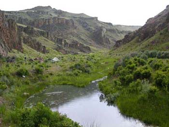
of optimism, we set up the tent beneath blue sky (N41 15' 19.4",
W119 23' 34.5"). (See Opening Photo).
I tossed a line over a rock projecting from the cliff face and
hung the food bags, although bears were unlikely in that treeless
land. Then we cut firewood from a thick stump of sage with the
new pocket chainsaw. We ate an early supper, just in case.
Barbara worried that in a mountain deluge the
creek might rise. A flash flood might wash us away. I treated
the possibility as remote, pointing out that the creek would
have to rise five feet to threaten our tent. Besides, the weather
forecast predicted that skies were bound to clear.
After dinner the sky grew ominously dark. Approaching
thunder and lightning crackled on the cliffs. Barbara dashed
into the tent as the first fat drops began to splatter. I found
shelter standing in the cleft beneath the rock face. The rain
fell in gusty sheets. The tent shook in the wind like a wet
puppy trying to whip loose its tether.
I heard a droning howl I thought at first was
an owl, but the sound began to rise and fall like an old Indian
chant. "What the hell." My eyes explored the
cliffs and canyons for a lurking band of renegades. Nothing.
Straining to hear through the rain and wind, I thought the sound
was coming from the tent.
"Are you saying something," I
yelled into the gale.
"Can't . . . hear you," Barbara
yelled back. "Turn on . . . radio."
I found the radio in my pack and turned it on.
"Are you saying something?"
"Oh . . . ." There was a pause. "I
was just beseeching the clouds to go away." Another pause.
"I didn't know you could hear me."
I howled. Barbara howled. The wind continued to
howl. Soon the howling ended and the rain let up. Barbara crawled
out of the tent into a newly washed world. A few rays of dazzling
sunlight glanced from the west, warming, but too feeble to dry.
The storm had passed, and the humid air grew calm. Our wet tent
drooped, but the inside remained dry. I reinforced the corner
stakes with slabs of rock and tightened the lines. We crept
in early and, warm in our down bags and soothed by the patter
of intermittent showers on the taut rainfly, slept well.
 Friday
morning was magical. The canyon lay lush green and soaking in
the bright sun. Fat droplets clung to every stem and stalk,
reflecting each other like the jewels of Indra's web. We emerged
from our chrysalises and unfurled our wings to dry in a sunny
patch of grassland between the rock wall and the stream. Unhurried,
seated on our mats, we sipped our tea and mocha, listened to
a chorus of mourning doves and chukar, and traced the flight
of a flicker and peregrine falcon across the clear blue sky.
Ah, this! Nowhere better to be. Nothing better to do.
The world seemed right. In serene peace we ate our oatmeal and
dried fruit.
Friday
morning was magical. The canyon lay lush green and soaking in
the bright sun. Fat droplets clung to every stem and stalk,
reflecting each other like the jewels of Indra's web. We emerged
from our chrysalises and unfurled our wings to dry in a sunny
patch of grassland between the rock wall and the stream. Unhurried,
seated on our mats, we sipped our tea and mocha, listened to
a chorus of mourning doves and chukar, and traced the flight
of a flicker and peregrine falcon across the clear blue sky.
Ah, this! Nowhere better to be. Nothing better to do.
The world seemed right. In serene peace we ate our oatmeal and
dried fruit.
By midmorning the sun had dried our tent, but
storm clouds grew in the "V" of canyon to the west.
We decided to pack up and hike out. By noon, as we crossed the
creek near the canyon mouth, the drizzle began. A steady rain
fell as we climbed the road to the van. The rain soon ceased,
but patches of blue sky were being crowded out by waves of swelling
cumulus. It was time to move on.
A serious storm blackened clouds and closed in
around us as we fled south on Road 34 toward Gerlach, hoping
to cross the washes before they churned with flood waters. A
few miles before the last and deepest stream crossing, the deluge
hit. Rain poured down on the sage-covered hills and sheeted
off slickrock canyons. We managed to careen across the liquefied
gravel of the final stream bed before the water become impassible.
At Gerlach we stopped for lunch, then drove south
on the two-lane blacktop of Highway 447 into the eye of another
storm. Rain pelted the van until we passed through. The road
followed the eastern flank of the Fox Range to Winnemucca Lake,
another mostly dry playa remnant of Lake Lahontan cradled between
the Lake Range and the Nightingale Mountains. The high desert
was in bloom and a hatch of butterflies spattered our windshield.
The highway entered the Pyramid Lake Indian Reservation,
with its impoverished little towns and isolated, lonesome houses,
yards cluttered with junk and abandoned autos. Were these Paiutes
or Shoshone? We had no way of knowing, but sensed smouldering
resentment. The federal government's promise of Indian gaming
was no economic deliverance for Nevada tribes, where legal gambling
had long saturated the culture. Before long we passed Pyramid
Lake, whose lovely, wild, wind-waved surface stretched far to
the northwest. These sparkling waters formed the final sink
for the abundant flow of the Truckee River. White men had neglected
to steal this beautiful lake from the Native Americans. We wondered
why.
Finally leaving the reservation, the road crossed
the Truckee River at Wadsworth, and we felt ourselves spilling
down a rabbit hole into another world. Everything was in restless
motion. The I-80 corridor dazzled us with sodium lights, speeding
traffic, neon advertisements, and casinos. We had reentered
the realm of brash Nevadan hustle, where Boy Scout begat Boy
Scout and the sole moral principle was profit. Forgotten was
the drumbeat of the desert, the rhythm of the range, the voice
of the vanquished.
Entering Fernley was like descending into the
first circle of hell. The only vacancy we could find was at
a place called the TruckInn, a surreal combination of truck
stop, casino, motel, restaurant, and bar. A full-sized 18-wheeler
had been erected on a fifty-foot pole outside as a bizarre icon
of all the place had to offer. As we checked in, the clerk demanded
a deposit to obtain a television remote, which spoke darkly
of the usual clientele. In the hallways prowled unruly young
men with baseball caps and bulging tattoos, while wild girls
sauntered with exposed midriffs. We could not be certain that
bandits and psycho-killers lurked in the dimly lit corridors,
but we locked ourselves in our room until the morning sun drove
them all back underground.
Saturday morning we drove west on Interstate 80,
following the Truckee upriver. Everywhere the mountains had
been clawed open and their chalky insides mined. The naked hills
were defaced with roads, antennas, and ORV tracks. We glided
past the infamous Mustang Ranch. At Sparks we entered the brown
air of the Reno Valley. Bred in moist swamps along the river,
the Nevadan culture had proliferated like a slime mold and climbed
the valley walls. The freeway carved a path through the built
out, paved over, and wanton sprawl. We escaped north on Highway
395 into California.
Return to Backpacking
in Jefferson